Redwood or Kindling
Cascading climatic changes increase wildfire risk in the Redwood Belt
by Katie Anastas
Rising temperatures, resultant climatic shifts, and poor mitigation history set the stage for potentially catastrophic fires in the Santa Cruz Mountains and along the Big Sur Coast, the southern extension of California’s iconic redwood belt.
Redwoods occupy an east facing hillside in Ventana Wilderness along the Big Sur coast, Jan. 3, 2020.
It wasn’t until a message arrived from Rose Joseph, a friend from Berkeley, that the severity of the Kincade Fire became clear. High winds were pushing the new burn a mile from her home in Healdsburg, California, and her family braced for catastrophe. “The area’s been under mandatory evacuation since yesterday,” she wrote. “Winds last night/this morning were clocked at 80mph and the fire is only about 10 percent contained. We had hoped for the best, but also prepared for the worst, and have no real updates at this time besides that.” They got to the house before the fire did, and loaded their truck with memorabilia—family photos, art, indications of days spent picking grapes and playing on the handmade swing they tied to an old oak that overlooked the property. They left the house and the town to chance, clinging to a sliver of hope that their property would be spared.
Over the nearly two weeks Kincade was active, it burned almost 78,000 acres of Sonoma County. It destroyed and damaged over 400 structures, including more than 200 homes. The evacuation zones spanned from Glenview to the coast at Bodega Bay. Over 186,000 people left the county, among them, the small community of Guerneville, a logging town turned vacationing spot famous for its proximity to the Russian River and redwood forest.
Healdsburg’s scorched landscape post- Kincade, Oct. 2019. Photo by Rose Joseph.
The redwood belt and communities that inhabit it have not historically been at risk for high-intensity fires. Redwoods are resilient, flourishing for over 20 million years along the California coast. They have thrived in cool, precipitation-rich environments generally free of the desiccated plant material, high winds, and dry air conducive to starting and spreading fire, but those places are starting to disappear. As earth’s climate continues to change, warmer temperatures and heightened water-stress prompt a series of interconnected consequences – susceptibility to drought, disease and insect attack, stunted growth, and old-growth death – all of which put the redwood belt at risk.
No longer can redwoods rely on the climate to protect them from cataclysmic blazes. Extreme drought, a decrease in fog cover, and average temperatures that have risen by around 2 degrees over the last 50 years are threatening the more vulnerable portions of the redwood belt, most glaringly the southern extension into Big Sur, Monterey County, and the Santa Cruz Mountains. They have altered the way state authorities and local communities think and respond to fire in previously low risk areas of California. “To actually do comprehensive, across the board fuels reduction that this state desperately needs,” former CalFire historian Mark V. Thornton said. “That isn’t happening.”
California Coastal Redwoods are the tallest trees on earth. They grow up to 380 feet high, can live for more than 2,500 years, and only grow naturally in the California Redwood Belt, which extends from Southern Oregon to Central California. The trees fall into several categories of growth depending on their size and age – old growth, secondary growth, and new growth. Old growth refers to the tallest and most mature portions of the forest. Secondary growth is the regrowth after a timber or logging harvest that is no longer discernible from non-disturbed portions of the forest. New growth is also regrowth, however it stands out from the forest as smaller and less mature. The growth present within the redwood belt is so large and so dense that the region is potentially sequestering up to three to five times more carbon than the Amazon. That is, redwoods are carbon sinks. They absorb monumental amounts of carbon from the atmosphere.
This portion of the coast falls in the California Floristic Province, a Mediterranean climatic zone with wet, cool winters and dry summers. Michael Kauffmann, a conifer specialist, explained that within the belt, the distribution of redwoods can be separated into three regions. The northern extension, beginning in southwest Oregon, reports higher rainfall and cool temperatures. The middle, ranging from Sonoma County to south of San Francisco, features thick and relatively complete forests like Muir Woods, and incomplete forests, varied landscapes, and warmer, drier weather characterize the southern extension – Monterey County, Big Sur, the Santa Cruz Mountains.
Their habitat distribution parallels the California Current upwelling zone, portions of the California Current where wind-driven cool, nutrient rich water displaces warmer surface water. While redwoods are largely watered by winter rains that residually drain through steep coastal watersheds, fog banks, the result of coastal upwelling, are their primary summer water source – redwood forests across the entire belt are found in areas that experience over nine hours of fog daily during the summer. “It’s a very important water subsidy that they get,” said redwood ecology specialist Todd Dawson. Fog, he said, “really affects their growth, their physiology, of everything not just the redwoods, but all the understory plants and probably many of the animals that also live in the redwood forest.”
Kauffmann said that climatically, the northern extension has better access to water resources like fog and rain, contributing to a more homogenous forest and making it less subject to change and fire risk. Especially in the northern extension, preserved spaces like Humboldt County’s Redwood National Park are relatively unsusceptible to wildfires and thus preserve much of the redwood belt’s old and secondary growth.
Redwoods occupy a riparian zone in Big Sur, Jan. 3, 2020.
That is not true at the southern end of the redwood belt, where the frequency of summer fog is slightly lower and temperatures are higher. Redwood distribution in regions like Big Sur and the Santa Cruz mountains are patchy, isolated to riparian zones, which are the transitional spaces between land and water surrounding rivers and streams, or south-facing slopes. Rather than dense forest, various grasses, trees, and drier plant materials like chaparral and California live oaks surround the southern redwoods, all of which are more susceptible to high intensity fire than redwood itself. “When you have this more patchy, less homogenous ecosystem,” Kauffman said, “when you have different vegetation types next to each other, there is a greater chance that fire could be vectored into a redwood forest.”
Even though flammable plant materials surround the southern redwoods, they remain relatively resistant to fire. Redwood has a relatively low BTU—that is, the amount of heat that will raise the temperature of a pound of water by one degree Fahrenheit. In other words, they do not burn easily. “A redwood falls on my property and I’m not that stoked about putting it in my wood stove unless I just want a little fire for ambiance,” Kauffmann said. “It doesn’t produce that much heat.” Fully grown trees are exceedingly tall, and mature redwood bark is thick enough to protect the body of the tree from fire. Even fire-affected trees can regrow.
A redwood burl sits on the floor of Butano State Park, Pescadero, Ca. Nov. 29, 2019.
Redwood trees can resprout from dormant stems located in burls they begin developing as seedlings. The burls are bulbous and knotted, a stark contrast to the height and verticality of redwoods themselves, but they offer a second chance. If a tree is damaged or falls, the burls can sprout, either sharing or taking over the parent tree’s root system. “They can be stimulated by any number of things, fire being one of them,” Kauffmann said. “If they’ve seen fire, you’ll often see these epicormic sprouts all over the tree. It’s just this amazing ability to resprout and regrow.” Sometimes, near complete “fairy rings” or “family circles” of new growth sprout from the basal burls of fallen or harvested parent trees. The new trees are genetic clones of the old.
Redwoods’ root systems also protect them from events like high-intensity fire. They have shallow roots that extend as far as 100 feet from the tree’s base and intertwine with neighboring trees. This creates an extensive, interconnected, and stable network that protects redwood forest from events like earthquakes, floods, wind, and fires.
There is a catch. Ecological adaptations like height, tick bark, and burls only really protect old growth redwoods. New growth and secondary growth are not dense enough to ward off fire damage the way old growth can. Not only that, but the height of this new growth is tall enough to transfer embers and flame to the crowns of more established trees, endangering the ecosystem as a whole and any surrounding communities. This is particularly troubling given how little old growth remains —only about 5 percent of the original trees remain in the belt, an after effect of extensive logging in the 19th century. All the rest is either secondary or new.
Small towns like Guerneville were built within these forests to capitalize on a rapidly expanding demand for redwood. Local lore suggests that at the time of its establishment, Guerneville had the highest biomass density on earth. Now, small storefronts, eclectically remnant of the 1950s, western false front architecture, and cabin style homes populate Guerneville’s rolling, redwood-forested hills. Tucked between trees and redwood groves, the town flourishes around the Russian River, which flows through Sonoma Valley. It’s made its name as a sleepy vacation town where travellers and locals spend hours lounging on beaches, swimming or floating along the river’s rocky shore, below bridges, down rapids, joined only by an occasional duck and the trees towering above them. I’ve spent days there, jumping off of rocks into deep sections of the river and trailing sword fern fronds across the water’s surface, perhaps stopping for homemade cherry ice cream on the drive home if the time seemed right. Guerneville also made a name for itself as a LGBTQ+ getaway, hosting annual events like Lazy Bear Week.
Although the town still thrives among the redwoods, the ecosystem there is not as robust as it once was. So many redwoods were cut down during the logging boom that the town received the nickname “Stumptown,” a moniker still celebrated annually with a town parade called “Stumptown Days.” The mill, formerly located where Armstrong Redwoods State Natural Reserve now stands, produced nearly five million board feet of lumber each year, decimating the old-growth ecosystem. Save Armstrong Redwoods SNR, which preserves most of Guerneville’s old growth, much of the redwood forest in Guerneville’s environs is newer growth. As a result, the local ecosystem is more susceptible to climatic changes, increasing the risk of fires like Kincade Fire.
![]()
Changes in climate compound the problems the lack of old growth generates. Temperatures run higher; water resources like snowpack and watershed volume are more limited, and the frequency of drought is higher. Most glaringly, coastal fog has decreased markedly over the last century. Fog frequency changes depending on the temperature difference between the coast and inland California. When the temperature difference is large fog frequency increases, and when it is small fog frequency declines. This temperature difference has declined by around 4 degrees, contributing to a 30 to 35 percent difference in summer fog frequency.
This is concerning because redwoods rely on summer fog to preserve their habitat. It supplements the lack of regional rainfall, acting as a primary water resource during the summer season. Dawson said that as temperatures on earth and the sea surface warm up, “it leads to conditions that are not very favorable for fog formation off the coast.” The amount of daily summer time fog has decreased by around three hours. “It used to be something like between 12 and 13 hours of fog every single day and now it’s down to like nine,” Dawson explained. Without enough fog, he said, there is no “humidifying effect. You have more atmospheric water deficit, which is pulling water out of the trees, out of the soils, and that then can lead to even further … stress in plants and animals caused not only by no fog drip going into the system, but because of these sort of evaporative conditions that are pulling water out of the system that normally don’t occur during the summer.”
Pull-quote flush right: “The ones in the very marginal dry habitats . . . they were the only places in the Coast Range where redwood trees actually died.”
It follows that the drier forests become, the more at risk they are for drought-induced effects. Declining fog levels mean more exposure to sunshine. As a result, trees in the northern extension of the range are experiencing a surprising increase in growth, likely because they have more hours of daily sun and they receive enough winter rain to offset the water stress fog decline has caused. This is not the case in the southern extension, where the opposite has occurred. “It’s the one place through tree-ring analysis that we’ve seen the trees’ actual growth being very much affected,” Dawson said. “During the drought that occurred between 2012 and 2015, some of those trees actually died. The ones in the very marginal dry habitats . . . they were the only places in the Coast Range where redwood trees actually died.”
The death described by Dawson was not limited to secondary growth. The drought, changes in rainfall, higher temperatures, and decline in fog even affected areas of relatively pristine first growth redwoods in the Big Sur area. The ever-shifting climate only compounds dangers like stunted growth in the southern extension, and exaggerates fire risk in the region as a whole. “If it gets very dry, particularly kind of on the Eastern margins of the coastal Forest, [redwoods] could become much more susceptible to things like wildfires,” Dawson said. “On their eastern border, in a very dry interface with oak savannas and oak woodlands, if those areas get hotter and drier yet because the fog has been on the decline, then it really can put the redwood forest at risk.”
Redwoods themselves are generally not prone to sparking regardless of growth, however the dry plant material surrounding them is. This places heterogenous redwood forests like those in the Santa Cruz mountains and Big Sur—for instance Los Padres National Forest—at a higher risk for large, intense burns than the more complete forests in the northern portion of the state. Los Padres National Forest doesn’t look like a traditional redwood forest. It is large and diverse, with landscapes that stretch from the Big Sur Coast to Ventura, grasslands to pinyon-juniper woodland. Among these landscapes, however, are the world’s southernmost naturally occurring redwoods, which line the canyon bottoms and north-facing slopes of the Ventana and Silver Creek Wilderness regions. Unlike Big Basin or Muir Woods, they remain relatively isolated from foot traffic. There are no direct trails into the groves, and existing ones are faint, eroded by streams and rain or heavily overgrown, maintained only by passing hikers and backpackers.
I visited Ventana Wilderness at the beginning of this year to try to find some of these giants. It was a miracle we even found our trail. Just a small sign on the edge of California State Route 1, Vicente Flat trailhead is in the middle of a service deadzone. Our only map was a sheet of paper our campsite manager printed and highlighted for us earlier that morning. After confirming we were in the right place, we parked on the side of The 1 and gathered our things, my camera and enough water to last 11 miles and 2400 feet of elevation change – it was dry, clear and just a bit warmer than a regular January day on the coast. As we made our way to the entrance, confusion set in. Dead grass and chaparral thicket lined the trail, which was unusual for redwood habitat. It wrapped up and around the canyonside in full sun, past shrubs and rock faces rather than moss and giant conifers. Undeterred, we continued, hoping the trees were farther along the trail.
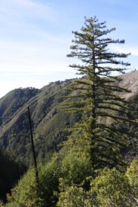
Two redwoods, one dead and the other scarred from fire, stand among bushels of regrowth in Ventana Wilderness, Los Padres National Forest. Jan. 3, 2020.
Suddenly, the temperature dropped. We were completely shaded, our path damp and the plants greener. We looked around to find the source, but nothing near us was tall enough to create the shadow we were standing in. We looked up, and there they were. A grove of enormous trees stood alone on the ridge in front of us, lording over every cliff and wave break hundreds of feet below them. It made no sense—a single grove of redwoods in full sun with no direct source of water—but at least we knew we were in the right place. The landscape continued to evolve alongside our elevation. Chaparral changed to oak, oak to yucca, yucca to grassy hillsides. Finally we made it to large swaths of redwood groves, isolated to the canyon’s interior. We noticed a strange, ashy tint to the trees’ bark. As we moved closer we realized they were burn scars. Nearly every large redwood in the canyon sported them in some fashion, charred trunks, fallen branches, toppled trees. Some just stood, skeletons, defiant in death with new growth forming at their roots. We had stumbled on the site of the Basin Complex Fire, one of the largest wildland fires in California’s history.
Unlike the majority of Northern California’s recent fire catastrophes, the Basin Complex Fire was not started by human activity. Rather, it was a byproduct of the 2008 Northern California Lightning Siege. On Saturday afternoon, June 21, 2008, a large thunderstorm rolled onto the Big Sur coast. Over the storm’s course, it unleashed more than 8,000 dry lighting strikes and started almost 2,700 fires across drought-affected California. As the storm initially moved onto land, a series of dry lightning strikes lit multiple fires within miles of each other. These fires merged into the Basin Complex Fire. The fire initially seared 163,000 acres of the Big Sur Coast on its own, however fire authorities redirected it and merged it again with the Indians Fire, another earlier, man-made blaze. The Basin Complex-Indian Fire destroyed nearly 245,000 acres combined, 90 percent of it situated in Los Padres National Forest’s Ventana Wilderness.
Dry conditions like those present during the destructive 2008 wildfire season render surrounding vegetation susceptible to drought-induced effects like flammability, insect attack and disease. Other native trees like ponderosa pines are more at risk for bark beetles and other wood- burrowing species. While bark beetles are native to California, they attack and at times kill trees weakened during drought, or by injury and diseases like sudden oak death. During California’s historic drought, bark beetles destroyed millions of acres of trees across the state, according to the US Forest Service. Forest Service entomologist Cynthia Snyder described the devastation in an interview with Good Times, Santa Cruz County’s weekly newspaper, noting that beetle attacks had killed more than two million trees over 820,000 acres in 2014 alone. This surplus of dead plant material creates excess biofuel for intense wildfires in already at risk, drought-stricken regions of the state.
Sudden oak death disease, which contributes to increases in biofuel loads, is another scourge. It was discovered in 1995 in Mill Valley, a secluded suburban town in Marin County just four miles from Muir Woods, and thrives in the fog belt’s coastal evergreen and tanoak/redwood forests. The pathogen is known to cause mortality in tanoaks and other California oak species, as well as different twig and foliar diseases in various other native and non-native flora like California bay laurels and redwoods. It currently infects 14 counties along California’s coast, and has killed more than 50 million oaks and tanoaks over the past two decades. In 2019, SOD Blitz, a US Forest Service-funded program led by Matteo Garbelotto, a forest pathology specialist, identified an increase in infection rate from 6 to 18 percent on the western slopes of the Santa Cruz Mountains. The program also re-identified a chronic outbreak in Big Sur.
Although live oaks, like redwoods, are not generally fire prone, dead oaks provide significant biofuel for intense blazes like Kincade. “California is more susceptible to larger and hotter fires, specifically because of the large number of dying oaks, which are basically match sticks,” said Garbelotto in an 2017 interview with Peter Fimrite for SFGate. “We have these large swaths of forest with a large number of infected oaks and tanoaks. Even when they are not dead, their moisture content is much lower than a healthy tree.” Garbelotto was not available for comment.
Long intense dry spells like in 2008 and California’s historic drought, which lasted from December 27, 2011 to March 5, 2019 and is now believed to be part of a megadrought ravaging the western United States, and the higher temperatures they bring also enhance the fire risk across the state. Chris Dicus, president of the Association for Fire Ecology, said just over the years of his career as a fire professional, he has watched the state’s fire season elongate drastically. Fire season historically lasted from June until late August. “It’s year round now,” Dicus said. “We’ve had destructive wildfires in February, and that’s something that was completely unheard of when I started 20 years ago.”
Pull-quote flush left : “You don’t want fire to play its natural role in the interface. It’s going to burn down the world.”
Dicus had a sense of humor. Even though the subject of our conversation was heavy, he laughed when he spoke. The twang in his voice was reminiscent of his self-proclaimed hillbilly adolescent self from Hot Springs, Arkansas. He wore a full suit and a full grin, his blonde hair slightly tousled. The office was full of books about fire ecology and what I assumed to be souvenirs and memorabilia from Dicus’ firefighting career. A helmet hung from his bookshelf, and a photo of palm trees going up in flames shone bright on his computer desktop. Dicus’s interest in firefighting blossomed after Yellowstone’s Old Faithful Inn nearly burned down in 1988. He now specializes in wildland-urban interface fires, which occur in transitional areas between natural and human-developed landscapes. “Lets let fire play its natural role,” Dicus said, “but you don’t want fire to play its natural role in the interface. It’s going to burn down the world.”
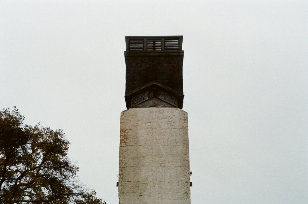
A chimney is all that remains of a Healdsburg home that burned during Kincade Fire, Oct, 2019. Photo by Rose Joseph.
The expansion of the wildland-urban interface and role of land use in the southern extension of the redwood belt will likely further complicate and exacerbate emerging problems caused by climatic changes. Increased population growth and development in areas like Santa Cruz and Monterey Counties pose a challenge to fire management and safety in those portions of the redwood belt. Since the gold rush, approximately 27 percent of the original coast redwood ecosystem was lost due to human development – around 40 percent of the remaining forest is fragmented by development, agriculture, and roads, creating degraded habitat quality. Less than a quarter of California’s coastal redwood ecosystem is protected from development, subdivision, or commercial logging.
This expansion in population also impacts the mitigation strategies fire officials can carry out in the region. “By far the best thing to reduce surface fuels is to have a prescribed fire,” Dicus said. “But sometimes we can’t do that, you know. You’re next to a community and smoke is a huge, huge issue… The more ownerships you have, the more land owners you have to convince.” Currently, 88 percent of the redwood belt is burning at a lower frequency than before European settlement, exacerbating the accumulation of biofuel.
Sweeping mitigation plans are necessary to remove the increasingly substantial amounts of biofuel present in redwood ecosystems, and remedy climate-related damage and its consequences. However until recently, extensive and effective fuel reduction programs were not California’s priority. California’s Department of Forestry and Fire Protection, CalFire, instead focused on the suppression of all emerging wildfires, inadvertently setting the stage for these disastrous, high intensity wildfires. Mark V. Thronton, a former CalFire historian, expanded on the severity of this risk during a phone call with me last November. “When you have the cumulative impact of the buildup of forest fuels because of the absence of regular fire, and then you couple that with the known potential for California to go into more hostile weather patterns [heat waves, dry wind, lighting seizures], we’re now in a huge predicament today,” Thornton said. “There’s not a community in California now that has not been directly or indirectly affected by a bad fire in the last 30 years.”
CalFire protects and manages over 31 million acres of the state’s privately owned and public wildlands, approximately 43 percent of the state’s forested area. It is the second largest municipal fire department in the country, and also maintains contracts with 36 of California’s 58 counties to provide emergency services like disaster mitigation and rescue crews. These counties include Sonoma, site of some of the state’s most devastating fires, such as the 2017 Tubbs and 2019 Kincade Fires. It also includes Butte County, the location of Camp Fire, the most devastating wildfire in state history.
Historically, the strategy for California’s forest service has relied on the goals of what is called timbershed and watershed management. The strategy to manage timbershed was initially devised to “preserve and conserve” the state’s forested areas from “timber famine,” a byproduct of the logging industry. It also focused on preventing potential wildland loss in the period of western expansion in the 1800s. The main goal of watershed management strategy was to protect California’s emerging agricultural industry from natural phenomena like flooding and mudslides.
Though the two differ dramatically, their commonality was the shared objective of preventing wildfire damage and minimizing other fire-related destruction. Thornton spoke of the many decades it took to understand the original management policies, first formulated in 1905, which initially paralleled those of the U.S. Department of Agriculture. “The California department of forestry was really a cousin and a stepchild in the forest services efforts,” he said. In 1923, a devastating fire in the Berkeley Hills burned 800 structures to the ground, becoming the impetus for CalFire’s emergence as an independent state governmental unit. Total suppression of fires became the goal, which also appeased the concerns of the logging industry and California’s growing population more generally. CalFire moved to extinguish even smaller, low-intensive fires that would otherwise have burned themselves out naturally. They even stopped using the strategy of prescribed fires—that is, burning specific areas to prevent higher intensity blazes from sparking. As a result, California’s biofuel levels exploded. “The only thing that’s keeping this place from going up like a nuclear bomb,” Dicus said, “is the weather.”
Increasingly common dry wind and heat waves dictate the way CalFire prepares for and approaches large fires, from aircraft, hand crews and engines to safety and public evacuation procedures. Scott McLean, CalFire’s communications director, emphasized that much of CalFire’s success in conducting biofuel elimination rests on weather patterns and pure luck. “The weather has been beautiful here in the beginning part of the year,” McLean said, “not like it was the last two years where it was a hundred degrees for several weeks at a time.” Recent fluctuations in weather across the state have also contributed to the significant increase in biofuel build-up. “Unfortunately [the drought] promoted a lot of growth of the grasses and smaller vegetation that’s very susceptible to fire,” McLean said, “and then we saw what happened in 2017 with the major fires in the state. Same thing happened in 2018 and we continued to break records.” This February was the driest on record.
In an attempt to remedy this managerial misstep, however, CalFire recently stepped away from its traditional strategy of fire suppression in favor of new initiatives for managing natural resources like prescribed burns and the expansion of forest assistance programs. These changes are in part thanks to Gov. Gavin Newsom’s 2019 executive order that details short, medium and long-term strategies to mitigate and prevent destructive wildfires. The plan alters the way CalFire addresses forest and fire management now and long term, significantly increasing available resources and funding, and enhances the department’s ability to respond to and contain high intensity fires like those in 2017 and 2018.
Rather than relying solely on fire suppression, the executive order calls for a series of initiatives to protect over 25 million acres of wildland now classified as “under very high or extreme fire threat,” and their populations. These initiatives include a series of 35 fuel reduction projects that help decrease public safety risks for over 200 of the state’s most vulnerable communities, based on socioeconomic factors like income, age, language and mobility. It also includes community education plans, the development of fire mitigation and management research, and provides temporary housing for those displaced by large blazes like the Tubbs Fire. McLean said fuel reduction and forest management projects have always been part of CalFire’s work, “but this year, we’ve been given so much more help and it’s just really bolstering our capabilities.”
In addition to these administrative and policy initiatives, Newsom provided CalFire with the funds to hire an additional 400 seasonal firefighters to prepare for 2019’s fire season, to maintain ten fire reduction crews, and to bring on 110 national guard troops to help with fuel reduction. This is crucial to CalFire’s “seasonal” fire fighting ability. Seasonal firefighter’s contracts stipulate nine months of duty, but in the past, the length of California’s fire season only required five months of work. The department is also updating it firefighting mechanisms, including the introduction of 12 new Blackhawk helicopters, seven C130’s – which carry 4,000 gallons return – 13 new fire engines, as well as an increase in the emergency funds at the department’s disposal, which are used to respond to the highest intensity blazes. “It will never end,” McLean said.
Newsom and CalFire’s plan means to address the quickly emerging needs of the state, although not without public skepticism. “Are there successes out there with these agencies?” former CalFire historian Mark V. Thornton asked rhetorically. “Absolutely. Are the failures? I think there are.” For one, the lack of federal funding for wildfire mitigation is a serious hindrance on CalFire. About a third of California’s land mass is under USDA control. While CalFire does work with the federal government, USDA resources are relatively limited and getting smaller. Between 2019 and 2020, the government cut national Wildland Fire Management allocations by over $500 million and similarly diminished funding for fire research and forest management.
Furthermore, Newsom’s bill fails to directly regulate private businesses like PG&E, one of California’s major utility providers, that increased fire probability in at risk areas by neglecting to upkeep its electrical network. This oversight is remarkably detrimental to the future of fire mitigation and limits CalFire’s ability to adequately respond to burn sights. According to the Wall Street Journal, PG&E was responsible for over 1,500 wildfires between 2014 and 2017, including the historic Camp Fire and Tubbs Fire, which burned adjacent to the redwood belt in Sonoma County. “In California and literally throughout the world,” Dicus said, “90 percent of ignitions are people caused.”
![]()
Aside from CalFire, the USDA, and their resources, California’s fire mitigation largely depends on local crews. Counties dictate what policies are enforced and how funding is allocated to prepare for potentially devastating fires. However, these local initiatives or lack thereof aren’t always successful, leaving residents to pick up the slack. This was the case for Erik Shahoian, a Napa County resident, when his house ended up on the frontline of the 2017 North Bay Fires.
Erik Shahoian’s home was more garage than house. The former engineer moved to Napa from the Bay Area nearly eight years ago, hoping for a slower life and an opportunity to build race cars. He found his place in a small community in Napa Valley, made up of warehouses, vineyards, grazing pastures and a small diner. His property sat at the end of a thin cracked road, lined by a wall of eucalyptus that divided the farmland from acres of marsh. That dream shattered, however, in October, 2017, when a cluster of destructive fires assaulted Napa Valley and the North Bay. Propelled by 80 mile-an-hour Santa Ana winds, the firestorm nearly reached Erik’s home. He and his wife only had enough time to grab a change of clothes, water, and load their animals – two bunnies, three chickens, three cats, and two dogs – into their truck before evacuating the area. It was arduous. There was only one road out, and the family had to drive towards the fire to escape it. Luckily, they made it past the flames, and the neighboring vineyards aided as a natural fire break. Their house survived the inferno. “I was a city boy,” Shahoian said, “and I really didn’t know what I was getting myself into moving here.”
As I later found out from Erik, the county doesn’t do a lot to mitigate fire danger. Specifically, the eucalyptus trees are a huge hazard. Highly invasive trees initially brought to California from Australia as natural wind walls for developing towns, eucalyptus are extremely flammable. Firestorms are brief, but embers remain in the trees, and although those next to Erik’s are on county property, the county doesn’t maintain them at all. Erik has to trim them to try and manage a near endless source of fire starting debris.The roads are poorly maintained, cracked and misshapen from years of neglect. The local fire department can’t help people during emergencies like the 2017 fires because they’re too busy fighting the fire itself. “People here won’t make changes,” he said, “until it gets worse.”
That was the case for voters in Santa Cruz County Area 48, who approved a property tax increase in January that would improve fire services in their area. The property tax increase is slated to raise an additional $1.5 million for the Santa Cruz County Fire Department to increase the scope of its resources and hire new personnel. Before the tax increase was passed, CSA 48 had 25 percent fewer paid and 45 percent fewer volunteer staff members than they did 10 years earlier, despite a 22 percent emergency call increase. The department was so short staffed that in 2018 there were more than 55 instances where all firefighters were out on emergency incidents and could not respond to incoming calls. Area 48 is home to more than 24,000 people and covers 286 square miles of unincorporated, rural country land, including the redwood populated areas of Bonny Doon and Loma Prieta. Nearly all of it is considered to be at high fire risk.
Other localities employ more traditional fire management strategies to mitigate fire risk. In a different part of Santa Cruz County, prescribed burning has been a staple of fire mitigation for a quarter of a century. Big Basin State Park, California’s oldest state park and a large old growth redwood reserve, maintains a rigorous prescribed burn regimen to reduce its biofuel load. Tim Hyland, a California State Park’s environmental scientist and member of the team responsible for this regimen, spoke to the importance of fuel reduction in the park, how redwoods contribute an incredible amount to biofuel loads, and what that means for their ecosystems. “Although the tree doesn’t have any resin in it and is very resistant to damage from fire,” Hyland said, “the leaf litter is actually very flammable . . . They actually propagate fire.”
Without frequent fire intervals, Hyland said, lots of dead plant debris and understory growth accumulates, contributing to the fire sensitivity of the entire ecosystem. “With fire suppression, you know, effective fire suppression since the turn of the century,” he said, “you have fuel loads building up to the point where potentially these trees are at greater risk.” Unfortunately, over the last six years Hyland and his team haven’t been able to conduct burns as frequently because of climatic factors. “It’s either been too wet or too dry, or we haven’t had resources,” he said. Instead, they are focusing efforts on mechanical thinning and pile burning to continue reducing biomass in the park.
Reducing debris and biofuel loads is essential to reducing fire risk in forested communities like Bonny Doon, Ben Lomond, and Boulder Creek, the town adjacent to Big Basin. Although approving prescribed burns in populated areas is difficult, it’s not impossible. Sarah McCaffery, a USDA researcher who specializes in the social dynamics of fire management, stresses that the success of prescribed burn regimens in populated areas rests on the relationships fire officials build and foster with their communities. “The key variable in prescribed fire acceptance,” McCaffery said, “is trust in the competence of the person implementing the prescribed burn.” This trust and respect, she said, is largely born of public engagement, talking with homeowners about what they’re doing, why they’re doing it, and how it’ll benefit them and their neighboring ecosystem long term. “What matters more to people for that then the fire risk is the ecological benefits,” she said. “People know that fire is part of the ecosystem, that a lot of the species they care about, you know, actually benefit from the fire.”
Another, perhaps unlikely strategy for local mitigation rests on urban development. According to Tony Schafer, a former Los Angeles fire officer, around 2 million of the state’s approximately 11 million structures are under fire risk, and 75 percent of the structures lost in the last five years were in areas that burned for the first time. Nearly 90 percent were in areas that only burned twice. “Once a fire gets into a community with one or two structures,” Schafer said, “most of the risk is going to be structure to structure and not from the wildland fire.” Strengthening the wildland-urban interface and wildfire building codes, which previously were not really enforced, are crucial to reducing that risk. Chris Dicus suggests this is easier when new communities are built with fire in mind. “It actually has a chance,” Dicus said. “It’s going to be able to be a buffer as fire is moving across the landscape that actually might be used to protect the older communities that are fire prone,” primarily those built in the 60s and 70s.
Building communities with defensible space in mind, that is space around a structure that limits fire and ember exposure, is also essential to reducing fire risk in the interface. Sarah McCaffery, however, says it is hard to do so in more densely populated areas, and in those cases working alongside neighbors is a more realistic way to approach management in that capacity. “When you have houses that are close together, then they’re more likely to be the communities where people want to talk to their neighbors,” McCaffery said. “So those are communities where having some sort of program that gets neighbors to work together and sort of build a sense of community, those are more likely to be a useful way to go.”
One way communities are working together is by drafting evacuation and preparedness plans. Residents of Santa Cruz County are developing for severe fire emergencies despite relatively low concern, a byproduct of its relatively mild, foggy climate – even longtime residents of Santa Cruz Dan Orange and Bonnie Homer-Orange hadn’t noticed real changes. Although Dan recognized a warming central valley, he personally hadn’t noticed any real changes in coastal weather since moving to California in 1986. “Weather around here is noisy,” Dan said. “We have drier spells where the whole state is a little bit drier for a number of years. Yeah the state was drier, but we were at 90 percent of the Sierra snowpack on New Year’s Day.” His skepticism about a drier Santa Cruz informed Dan’s concerns about fire danger. Although large fires like the Camp Fire and action like PG&E’s wide sweeping power outages increased fire awareness among Santa Cruz’s populace, the county’s thick fog cover seemed to perfectly offset damage created by drought and rising temperatures. “How much of that is real risk?” he said. “I don’t know.”
Even still, the Oranges are involved with their friends’ emergency evacuation planning. “They finally sat down after the Paradise fire happened,” Bonnie said, “and then decided that they better let us know because their emergency plan is they’re all coming to our house.” The Oranges said their house seemed like a good evacuation checkpoint because it’s in walking distance for the kids and just far enough inland that it’s beyond the forest. “Everyone could get here no matter where they are,” she said.
Erik Shahoian, former engineer and Napa County resident, also decided to work with his community to prepare for another potential fire emergency. In response to his and his neighbors’ experiences, and the images of the Australian bush fires he later saw in the news, Erik decided to build a system that could protect his property from destructive fires. He reasoned a water pump system could delay fire damage – wet or damp objects don’t burn as quickly. He purchased a portable generator to power electric pumps that, when in use, hose his entire house down in under 10 minutes. The county does not supply enough water for this system, so Erik also purchased and filled extra water tanks to use for the pumps and to share with his neighbors, of whom he also has worked with to devise an evacuation plan. “The fact that people are doing anything,” Sarah McCaffery said, “it’s kind of amazing.”
Pull quote flush right: “I grew up in California, and I grew up with Smokey the Bear.”
Thriving alongside the countywide and individual fire mitigation and preparedness strategies present in the southern extension of the redwood belt is an effort to educate. Big Basin is opening their Big Basin Nature Museum and Nature Center later this year in partnership with Save The Redwoods League, a non-profit aimed at protecting and restoring redwood habitat, to make educational, immersive material about redwoods and their ecosystems more available to the public. Among that content is information about redwood’s relationship with fire. The main goal, environmental scientist and museum team member Tim Hyland said, is to give visitors “a new perspective on their role in the ecosystem.” Furthermore Smokey Bear, the most iconic image of California fire safety, still remains a symbol of wildfire preparedness and education. McCaffery said that Smokey works because of his simple message: be responsible when you’re in the woods, “only you can prevent wildfires.” That image and it’s clear message, Bonnie Homer-Orange said, is what really informed her about fire risk. “I grew up in California,” she said, “and I grew up with Smokey the Bear.”
While individuals can do their part to prevent wildfire, that isn’t always enough, and families like the Josephs find themselves in near impossible situations like Kincade. Instead of being spared, their house was out of reach of the firefighters in the center of the active burn site, and could only be monitored with online maps and updates. The fire burned relentlessly, and it was hours before they had eyes on their property again. Incredibly, their house stood unharmed, surrounded by scorched landscape and the remnants of their neighbors’ homes. The blaze was still raging elsewhere, but the sight offered their family a moment of repose. “We are so unbelievably lucky,” Rose said in an October Facebook update. “I almost can’t believe it.” While severe wildfires will continue to plague California as the state’s climate shifts, steps can be, and are being taken to remedy the past and plan for the future. Fire doesn’t mean the end for California, nor does it mean the end for redwood ecosystems and their residents. Change is possible, and although those changes may take time, the redwood belt will not go up in smoke.
![]()